Biodiversity assessment of environmentally sensitive species and habitats at SUA by Prashank Mishra'19
November 28th, 2018
Independent Study (ENVST 399)
Professor Robert Hamersley, Instructor
A. OBJECTIVE
The goal of this report is to help Soka University of America protect and preserve its natural and biological resources while following the university’s guiding principle to “foster leaders for the creative coexistence of nature and humanity”. The biodiversity assessment identifies and lists endangered and vulnerable species of flora and fauna that have potential to be found within the university boundary. The assessment also identifies environmentally sensitive areas/habitats on institutional land where such species might be found. Recommendations for a biodiversity management plan are proposed to the Campus Sustainability Committee of the Soka University of America as a biodiversity management plan. The assessment follows guidelines and definitions of terms in accordance with the AASHE (Association for the Advancement of Sustainability in Higher Education) STARS (Sustainability Tracking and Rating System) description of OP 10: Biodiversity credit (Appendix A).
B. IMPORTANCE OF BIODIVERSITY
Biological diversity, or biodiversity, is defined as the variety of all life forms (i.e. microorganisms, plants and animals) present in the Earth’s biosphere. Biodiversity encompasses three levels of organizations – ecosystems, species and genetics. It constitutes the diversity of species across ecosystems, diversity within species population and the diversity of genetic information and functional variances within species (Australian Museum 2015; MEA 2005; Morton and Hill 2014).
Biodiversity is essential for healthy functioning of ecosystems. It acts as the fundamental source of all ecosystem services pivotal to human sustenance and welfare. It plays an essential role in providing economic, ecological, scientific, cultural and recreational services. Diverse ecosystems have higher monetary value in the form of a variety of raw materials needed for medicine, food, construction or other industries that can add to the national or local economy (Morton and Hill 2014; Naeem et al 1999). Similarly, biodiversity allows efficient energy and nutrient recycling between various species and within ecosystems. These chemical and biological material flows contribute to ecological services such as greenhouse gas regulation, water purification, soil formation, plant pollination, pollution remediation, nitrogen fixation and so on (Lachman et al 2007; Naeem et al 1999). Furthermore, knowledge of biodiversity can help understand the science of the natural world, its processes and phenomenon. It can also help sustain cultural identities as most cultures have intrinsically evolved around nature. Lastly, rich biodiversity can add recreational value to an ecosystem thereby providing enhanced hiking and bird watching experiences, and economic profit through ecotourism (Morton and Hill 2014; UNEP 2007).
Globally, biodiversity is rapidly declining due to direct and indirect consequences of human activities. In the past century, the species extinction rate has increased by around 100 times compared to that of the pre-Anthropocene period. An estimated 10% to 50% of the higher taxonomic groups are currently threatened with extinction (MEA 2005). This huge loss of biodiversity can have negative impacts on human existence as it can result in inadequate ecosystem services and significant economic loss (Lachman 2007; MEA 2005). For instance, in the United States, a cumulative $2 billion worth of beehive loss is forcing farmers to adapt to more expensive commercial pollination (WH 2014). Therefore, declining biodiversity due to human activities necessitates the assessment of biodiversity at all levels, organizational, regional, national and global (IUCN 2000).
Assessment of biodiversity determines the richness, evenness and heterogeneity of living organisms in an area. Richness is measured by number of unique species. Evenness (or relative abundance) determines equitability among species by counting organisms within each species. And heterogeneity is the dissimilarity among species in an ecosystem. In order to protect, preserve and mange vulnerable habitats and wildlife, assessing status of extinction risks and trends of species population is necessary to evaluate the efficiency of conservation policies and biodiversity management strategies. Therefore, assessment is a prerequisite to implementing conservation plans and actions aimed to promote sustainable development (Bradley et al 2012; IUCN 2000).
C. PROJECT LOCATION AND ITS SIGNIFICANCE
Soka University of America, the study site for this project, is a non-profit, private liberal arts university. It is located in Orange County, California, in the city of Aliso Viejo which is about an hour driving distance north of San Diego and south of Los Angeles. It encompasses a geographical area of 103 acres within its boundaries and is situated at an elevation of 400 feet above the sea level. It is at an aerial distance of 3 miles from the Pacific Ocean and Laguna Beach. The university is situated at the southern end of Aliso and Wood Canyons Wilderness Park (AWCWP), thus, enjoying a view shed location along the eastern ridge of Wood Canyon. It shares 85% of its perimeter with the park (Orange County Parks 2009a; SUA 2018).
The AWCWP is a designated wilderness park managed by the Orange County Parks. It has an area of 3,873 acres and features diverse topography such as hills, canyons and floodplains that surround Aliso and Wood Canyons and sections of cliff area at the intersection of Laguna Canyon and El Toro. The park has an elevation ranging from 20 feet to 891 feet. It has a Y-shaped geographical configuration stretching out from El Toro Road and Laguna Canyon on the west to Moulton Parkway and Alicia parkway on the east. It shares borders with proximal urban settlements such as the cities of Laguna Niguel, Laguna Hills, Aliso Viejo, Laguna Beach, Dana point and Laguna Woods. The park falls under the South Coast Air Basin, one of the seven regional air basin areas designated by the California state government, which features semi-arid Mediterranean climate with warm and dry summers and moist winters and majority of rainfall occurring from November to April (Orange County Parks 2009a).
The AWCWP is a part of California Floristic Province which is a recognized biodiversity hotspot and genetic reserve in the North American continent (Orange County Parks 2009a). A biodiversity hotspot is a biogeographic region with at least 1,500 endemic vascular plant species that has lost at least 70% of its original habitat (Mittermeier et al 2011). Moreover, the park is also a part of a 17,000-acre regional coastal canyon ecosystem that comprises Laguna Coast Wilderness Park, Crystal Cove State Park and City of Irvine Open Space. It is linked to the surrounding wilderness parks by wildlife corridors that facilitate wildlife movement. The AWCWP provides habitats to various native species in the form of diverse and unique California landscapes such as oak and riparian woodlands, chaparral, scrub and grassland (Orange County Parks 2009b). Several state and federally listed species are also found in the park. Soka University, situated in close proximity of the park, therefore, holds responsibility to perform its operations without degrading or affecting the surrounding nature reserve of the AWCWP.
“
Aliso and Wood Canyons Wilderness Park is an environmentally sensitive area as it consists of various landscapes that support vulnerable biodiversity. The US Department of Agriculture refers to such areas as “fragile lands” defined as, “Those land or water areas containing ecosystems, possibly but not necessarily rare, that are sensitive to external stimuli which may disturb their balance, especially in an irreversible direction” (AASHE 2017; Schwartz et al 1976). Building upon this definition, AASHE (2017) lists 5 types of areas/regions that qualify as “fragile lands” or environmentally sensitive areas. The AWCWP qualifies for 2 of the 5 types of regions listed by AASHE. First, AWCWP is a “legally protected area”. AWCWP comes under the Central and Coastal Subregion of Orange County, California which is subject to California’s Natural Community Conservation Plan (NCCP) and federal Habitat Conservation Plan (HCP). The NCCP/HCP conserve and protect multiple landscape-scale regional habitats, including those of state and federally listed species, while allowing authorized land use (Cylinder et al. 2004; EMA 1996; Orange County Parks 2009b). Specifically, it focuses on 39 species that are indicators of ecosystem health. Secondly, as AWCWP is a part of a biodiversity hotspot (under California Floristic Province), it qualifies as one of the examples for the “regions of conservation importance” in AASHE (2017).
In the following section I describe the methodology used to identify environmentally sensitive areas and vulnerable/endangered species within the university’s owned land. My identification is primarily based on the information of the park’s landscapes and species provided in the Appendix C: Existing Conditions Report of the Aliso Wood Canyons and Wilderness Park’s Resource Management Plan (Orange County Parks 2009b). The resource management plan is published by the County of Orange in order to define programs that implements NCCP/HCP policies and provide a long-term management plan for the AWCWP to manage and protect the natural resources of the park while, simultaneously, providing recreational and educational opportunities to the local community (Orange County Parks 2009a).
D. METHODOLOGY
Environmentally sensitive areas
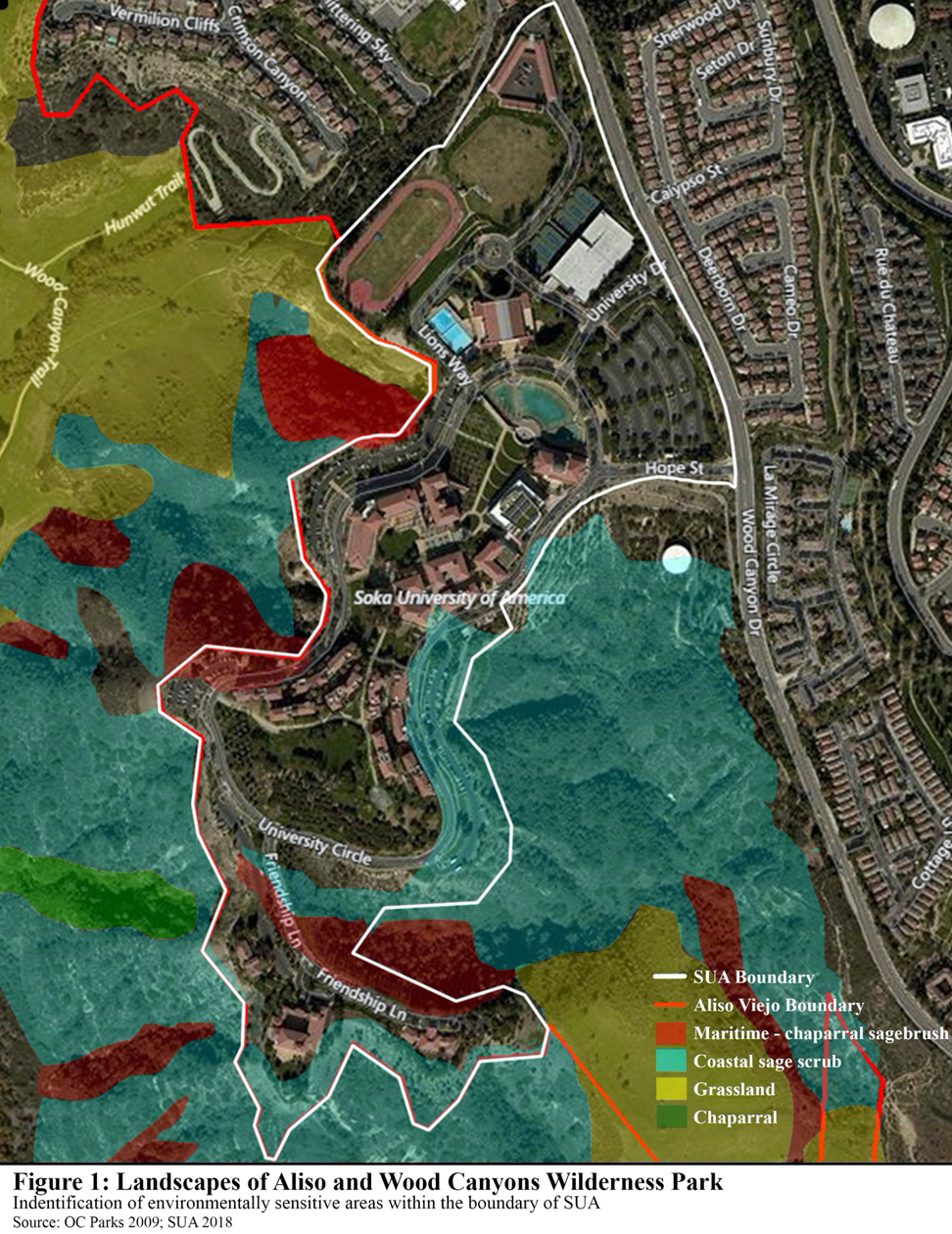
Since SUA shares 85% of its boundary with the AWCWP and the university’s natural habitats are contiguous with the park, the AWCWP landscapes that fall within the SUA boundary are considered as sensitive habitats. Therefore, in order to identify environmentally sensitive areas likely to exist on SUA owned land, I superimposed a map of the landscapes found in the AWCWP on a satellite image of the Soka University of America. SUA boundary outline was added. The areas of the vegetated communities lying within the perimeter of SUA were determined to be environmentally sensitive areas on campus.
Endangered and vulnerable species
In order to create a list of vulnerable and endangered species likely to be found within the institution’s perimeter, I analyzed the list of special interest species provided in the Existing Conditions Report for their habitat description and probability of occurrence in the AWCWP. Special interest species is referred to sensitive species are defined as the possible flora and fauna occurring in the park and designated as endangered or rare or of local (NCCP/HCP target and identified species) or state concern due to its rare or declining populations (Orange County Parks 2009b).
Environmentally sensitive areas can serve as habitats for species. Therefore, in order to determine the endangered and vulnerable species on campus, I used the types of landscapes found in the identified environmentally sensitive areas as the primary criteria to analyze the habitat descriptions and determine the likelihood of a habitat’s presence on campus.
Since natural areas within the SUA boundary are contiguous with the park, a habitat’s likelihood to be present on campus implied that a species is also likely to be found on campus. In addition, the occurrence probability of a species in the AWCWP was also taken into account. During my analysis, a species was likely to be found on campus, if its probability of occurrence in the AWCWP was above moderate and its habitat was likely to be present on campus. If the occurrence probability of a species was below moderate and its habitat was unlikely to be found on campus, the species was unlikely to be found on campus. A species of moderate probability of occurrence in the AWCWP whose habitat is likely to be present on campus was considered to be moderately likely to be found on campus.
Since plants are not mobile, I fixed 3 criteria to determine the likelihood of the presence of plant habitats on campus – vegetated community (landscape) type, county and elevation. Species with habitats in chaparral, grassland or scrub landscapes in Orange County at an elevation of 400 feet were considered likely to be found within the SUA boundary. California natives have also been planted purposefully on the university’s landscaped areas by Sequoia Environmental Services, the landscape management company for the Soka University of America. Sequoia Environmental Services provided a list of the natives planted on campus or found naturally within the perimeter of SUA. The list is excluded from my list of identified sensitive plant species but can be found in the Appendix C at the end of this report.
Both plants and animal species were then analyzed for their current status of extinction risk on a federal, state and local level using the list of special interest species in the AWCWP Resource Management Plan. In addition, I analyzed plants species for their risk status based on the California Native Plant Society (CNPS). The CNPS is a state recognized not-for-profit organization focused to conserve California native plants (CNPS 2014; Orange County Parks 2009b). On the other hand, I analyzed animal species for their international status of extinction risk based on the International Union for Conservation of Nature (IUCN). The IUCN is an international organization comprising of various governmental and non-governmental agencies to facilitate equitable and sustainable use of natural resources. The legends for all the status of risk of extinction is provided in the Appendix D of this report.
E. RESULTS
Environmentally Sensitive Areas
Coastal sage scrub, chaparral and grassland habitats of the AWCWP is found within the institutional borders (Figure 1). Maritime chaparral sagebrush which is a sub association of chaparral landscapes (Orange County Parks 2009b) is also observed within the SUA boundary.
Coastal sage scrub (CSS), also known as soft chaparral, consists of sparsely to densely populated, low growing, aromatic and drought deciduous shrubs growing on hill slopes and lowland bluff. These short drought and fire adapted aromatic shrubs make up the largest plant community in AWCWP. CSS is considered a sensitive habitat due to its high biological value. It provides food and shelter to a wide variety of reptiles, birds and mammals. However, it is increasingly become rare due to human development and, therefore, considered as one of the most endangered vegetation types in the state (Orange County Parks 2009a).
Chaparral is the second most vastly spread vegetation type. It is characterized by drought and fire adapted woody shrubs with thick evergreen leaves. Chaparral is also designated as a sensitive habitat but not as sensitive as CSS as it is extensively present in southern region of the park and does not support as much sensitive species as CSS. It is common habitat for rodents and mammals and some of the same reptiles and amphibians as found in CSS. One of the sub associations of chaparral found on SUA owned lands – Maritime chaparral is considered as a rare vegetation community (Orange County Parks 2009a).
Grassland spans significant portions of AWCWP and is characterized by dominant presence of annual and perennial grasses in low herbaceous vegetation. This is because grasslands lack vegetation where small animals such as rodents, small insects and other invertebrates can take shelter. Therefore, grasslands are commonly inhabited by birds of prey. However, mammal species are in abundance as they serve as a source of food for raptors. Historic human activities of grazing resulted in invasive species resistant to trampling, therefore forming one native and two non native sub associations of grassland.
Endangered and Vulnerable Species
There are 36 animal species and 26 plant species deemed by our methodology that are likely to have their habitat within the identified sensitive habitats of coastal sage scrub, chaparral and/or grassland.
Out of the 36 animal species, 32 of them are listed by the IUCN. Loggerhead shrike is designated a status of Near threatened (NT) and Tricolored blackbird is an Endangered species (EN). 30 other species are of least concern (LC). Federal classification recognizes Coastal California gnatcatcher as threatened. In terms of state classification, 21 of the 36 animal species are California Species of Special Concern (CSC) and 11 are assigned the status of Special Animal (SA). American peregrine falcon is classified as a state listed endangered (SA) and California State Fully Protected (CFP) and 15 out of 36 other species are listed as NCCP/HCP target and identified species.
In the plant kingdom, 2 out of 26 species are federally classified as threatened. They are Thread-leaved brodiaea and Laguna Beach dudleya. The latter is also one of the 2 state classified threatened species. The second state threatened species is Nuttall’s scrub oak. Thread-leaved brodiaea and San Bernandino Valley spine flower are the two state classified endangered species and 21 other species are state listed as Special Plant (SP). According to the CNPS conservation status 16 plant species are considered rare, threatened or endangered in California and elsewhere (1B), 4 as plants whose status is monitored by CNPS (4), 2 that are considered rare, threatened or endangered in California, but common in other parts of the world (2) and 1 species which requires more information to be declared as endangered (3). The full list of identified species can be found in Appendix E.
F. BIODIVERSITY MANAGEMENT PLAN
Due to the wide variety of classified flora and fauna whose habitat is likely to be on or adjacent to SUA, this report is proposing some strategies and policies to the Campus Sustainability Committee of Soka University of America. The proposal is divided into two sections. First section recommends steps that can be implemented immediately. The recommendations in second section would require planning, economic investment and consultation from an expert.
Section I
i. Prohibit littering and dumping of soil and waste on undeveloped land on perimeter slopes.
ii. Perform a clean-up of any unnatural substances and existent litter such as unused wires, fences, road signs etc. from the perimeter
Section II
i. Perform water quality analysis of storm water run-off for the transfer of nutrients and pollutants from campus operations into the canyon
ii. Plant native drought and fire resistant plant species on undeveloped lands to improve biodiversity and control erosion during rain events
iii. Identify areas of erosion and install soil swales and water bars to minimize erosion problems
iv. Remove all invasive and exotic species and create native habitat with California natives on the landscaped areas of campus
v. Create a review system for further developments to ensure trash is only collected at specific locations
vi. Collaborate with the Orange County Fire Authority to perform fuel load assessment to reduce fire hazards
References
[AASHE] Association for the Advancement of Sustainability in Higher Education. 2017. STARS Technical Manual. Philadelphia: AASHE. V.2.1
Australian Museum. 2015. What is Biodiversity [online]. Available from: https://australianmuseum.net.au/what-is-biodiversity. Accessed 2018 November 20.
Bradley JC, Duffy JE, Gonzalez A, Hooper DU, Perrings C, Venail P, Narwani A, Mace GM, Tilman D, Wardle DA, Kinzig AP, Daily GC, Loreau M, Grace JB, Larigauderie A, Srivastava DS, Naeem S. 2012. Biodiversity loss and its impact on humanity. Nature 486: 59-67.
[CNPS] California Native Plant Society. 2014. Independent Auditor’s Report. Sacramento: CNPS.
Cylinder P, Bogdan K, Zippin D. 2004. Understanding the Habitat Conservation Planning Process in California. Sacramento: Institute for Local Self Government.
[EMA] County of Orange Environmental Management Agency. 1996. Central and Coastal Subregion Natural Community Conservation Plan/Habitat Conservation Plan. Santa Ana: EMA.
[IUCN] International Union for Conservation of Nature Standards and Petitions Subcommittee. 2014. Guidelines for using the IUCN Red List Categories and Criteria. Gland: IUCN. Version 11.
Lachman BE, Wong A, Resetar SA. 2007. Appendix A: The Importance of Biodiversity. In: The Thin Green Line: An Assessment of DoD’s Readiness and Environmental Protection Initiative to Buffer Installation Encroachment. Santa Monica: RAND Corporation. p 107-110.
[MEA] Millennium Ecosystem Assessment. 2005. Ecosystems and Human Well-being: Biodiversity Synthesis. Washington DC: World Resources Institute.
Mittermeier RA, Turner WR, Larsen FW, Brook TM, Gascon C. 2011. Global Biodiversity Conservation: The Critical Role of Hotspots. In: Zachos F, Habel J, editor. Biodiversity Hotspots. Berlin: Springer. p 3-22.
Morton S, Hill R. 2014. What is biodiversity and why is it important? In: Morton S, Sheppard A, Lonsdale M, editor. Biodiversity. CSIRO Publishing. p 1-12.
Naeem S, Chapin III FS, Costanza R, Ehrlich PR, Golley FB, Hooper DU, Lawton JH, O’Neill RV, Mooney HA, Sala OE, Symstad AJ, Tilman D. 1999.
Biodiversity and Ecosystem Functioning: Maintaining Natural Life Support Processes. Issues in Ecology 4: 1-14.
Orange County Parks. 2009a. Aliso and Wood Canyons Wilderness Park Resource Management Plan. Irvine: LSA Associates.
Orange County Parks. 2009b. Appendix C: Existing Conditions Report. In: Aliso and Wood Canyons Wilderness Park Resource Management Plan. Irvine: LSA Associates.
Schwarz CF, Thor EC, Elsner GH. 1976. Wildlife Planning Glossary. Berkley: US Department of Agriculture. General Technical Report PSW-13.
[WH] The White House (US). 2014. Fact Sheet: The Economic Challenge Posed by Declining Pollinator Populations. Washington D.C: Office of the Press Secretary